Report: More Than 30 Million People Live in U.S. Floodplains
New data briefs released today from the NYU Furman Center shed light on the demographic characteristics of people living in the nation’s flood-prone areas and in the areas hit by Hurricanes Irma and Harvey. The data briefs are released amid uncertainty about the future of the National Flood Insurance Program, which is the sole provider of flood insurance for property owners in many parts of the U.S.
Following a short-term extension passed last week, federal lawmakers now have through December 22nd to negotiate a longer-term reauthorization for the National Flood Insurance Program. FloodzoneData.us and the accompanying data brief series describe the population and housing stock that would be affected by expiration of the National Flood Insurance Program—those living in the nation’s floodplains.
The first brief in the series, Housing in the U.S. Floodplains (PDF), describes characteristics of the housing stock located in the U.S. floodplains, including factors that are important for state and local governments and other policy analysts to understand as they assess the risk from flooding and the challenges of retrofitting homes in the floodplains.
The second brief in the series, Population in the U.S. Floodplains (PDF), explores the characteristics of the population located in the 100-year floodplain and the combined floodplain (100-year and 500-year floodplain), nationwide. In 2015, more than 30 million people (10% of the U.S. population) lived in the combined floodplain.
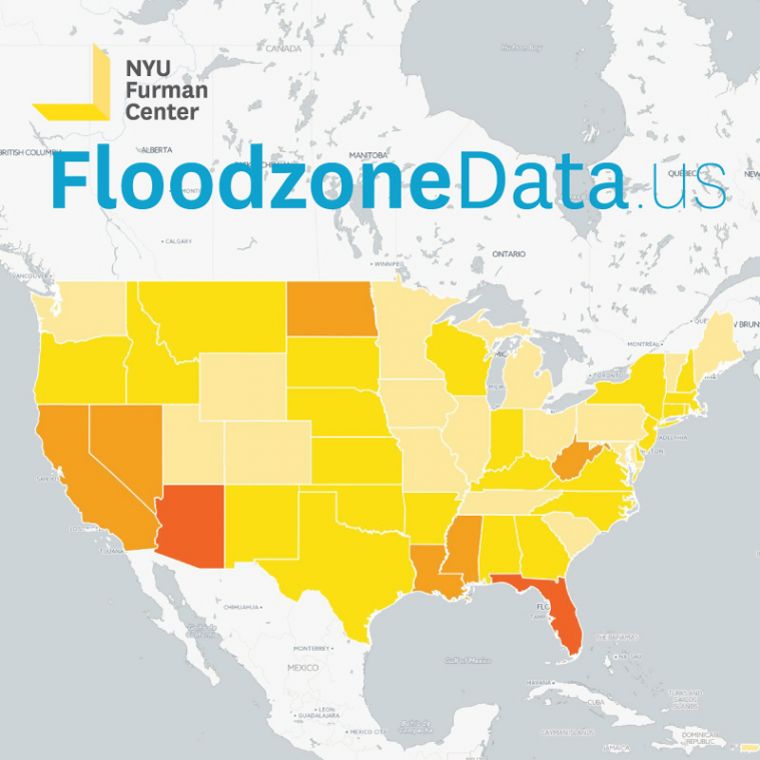
Two-thirds of the population living in the nation’s combined floodplain lived in one of five states: California, Florida, Arizona, Texas, and New York. An average of 15 million people nationwide (nearly 5% of the U.S. population) lived in the 100-year floodplain in 2015.
Contrary to popular conception that floodplains are mostly a problem for coastal areas, Arizona had the largest share of the population living in the combined floodplain (64%), followed by Florida (26%), North Dakota (20%), and Louisiana (17%). In the vast majority of states, less than 10% of the state’s population lived in the combined floodplain in 2015.
Nearly one-third of households in the 100-year floodplain include children and/or seniors. Of the households in the combined floodplain, 33% include children and 28% include seniors.
Compared to the U.S. population as a whole, a higher share of the population living in areas vulnerable to flooding identified as Hispanic (25% in floodplain vs 17% nationally), and a lower share of the population in the combined floodplain was white (55% in floodplain vs 62% nationally).
The third brief in the series, Population and Housing in the Floodplain Battered by Hurricanes Harvey and Irma (PDF), describes the housing and population located in the floodplains of metropolitan areas affected by hurricanes in recent months, including Houston, Miami, Tampa, and Jacksonville. The analysis describes the housing stock (including tenure, size, and number of subsidized housing units) and population demographics (including poverty rates, households with children and seniors, and race/ethnicity) in floodplains within these metro areas.
The NYU Furman Center’s three-part data brief series summarizes data from FloodzoneData.us, an online data tool describing the people and housing located in the nation’s floodplains. Launched earlier this year, FloodzoneData.us combines housing and population data with FEMA maps of the 100-year floodplain (the term for areas with a one percent probability of flooding each year) and the 500-year floodplain (areas with a 0.2 percent probability of flooding each year).
Read the press release: Report: More Than 30 Million People Live in U.S. Floodplains
Learn more at FloodzoneData.us >>
Webinar: Briefing on FloodzoneData.us
Wednesday, January 24, 2018 from 1:00 – 2:00 p.m. EST. | Register now >>
The webinar training will walk users through a demonstration of the data resources on FloodzoneData.us and include an overview of data trends from the accompanying brief series. The webinar is free and open to the public; advance registration is required.
Key Takeaways:
FloodzoneData.us Brief #2: Population in the U.S. Floodplains (PDF)
-
Just four states are home to the majority of the population living in the combined floodplain: Two-thirds of the population living in the nation’s combined floodplain lived in either California, Florida, Arizona, Texas, or New York in 2011-2015.
- States with the largest share of the population living in the combined floodplain were not on the coast: Arizona had the largest share of the population living in the combined floodplain (64%), followed by Florida (26%), North Dakota (20%), and Louisiana (17%).
- Compared to the overall U.S. population, a higher share of the population living in the combined floodplain identified as Hispanic. 25% of the population living in the combined floodplain identified as Hispanic, as compared to 17% nationally.
- 16% of the population living in the combined floodplain lived in poverty in 2011-2015. This is in line with the overall U.S. population, of which 15% lived in poverty in 2011-2015.
FloodzoneData.us Brief #3: Population and Housing in the Floodplain Battered by Hurricanes Harvey and Irma (PDF)
- Of the housing located in the U.S. floodplain, the share of single-family homes varies by state: 64% of Houston metro units, nearly half of Miami metro units, 34% of Tampa metro units, and 26% of Jacksonville metro units located in the combined 100- and 500-year floodplains are in single-family homes.
- The age of housing units in the floodplain, and thus how likely they are to be compliant with flood-specific construction standards, also varies by state: 12% of Houston metro area units, 16% of Miami metro area units, 13% of Tampa metro area units, and 16% of Jacksonville metro area units in the floodplain were built before 1960 (before FEMA created the National Flood Insurance Program in 1968). Units built since YEAR account for the smallest share (19%) of housing in the floodplain.
- Nearly 6,000 units of public housing are located in the combined 100- and 500-year floodplains in Houston, Miami, Tampa, and Jacksonville: More than 550 public housing units in Houston, more than 4,000 public housing units in Miami, about 500 public housing units in Tampa, and about 500 public housing units in Jacksonville were in the combined floodplains.